Monday 27 April 2015

Hinkley Point Lampshades

While walking the West Somerset Coast Path several years ago we came across poles in the fields near Hinkley Point Nuclear Power Station bearing lampshades and wondered what they were.  They are still there and I took a couple of photos of this pair of lampshades in April 2015 just outside the south west boundary of Hinkley Point near to Pixies' Mound.  We didn't spot any of the resident pixies - perhaps they have already upped and left, as it has become too noisy for them around their mound in recent months, due to all the preparatory work for the building of Hinkley C Power Station.   We did however have occasion to marvel at the wonderful camouflage of the male brimstone butterfly.  We watched one land on the leaves of a hawthorn bush but once it had closed its wings and stopped moving it was almost impossible to see it against the bright green leaves, as it was an almost perfect colour match.  

Back to the lampshades, the only information I can see online about them says that they are there for radiation monitoring purposes, which seems plausible given their location.  However it also seems a very primitive way of monitoring radiation in the 21st century! Still, sometimes the simplest ideas are the most effective.

Lampshades near Pixies' Mound

Memorial Hut, Selworthy Beacon

The Memorial Hut on Selworthy Beacon (grid reference SS 915 476) is also sometimes known as the Wind and Weather Hut.  It is a stone built shelter, erected in 1878 and built as a memorial to Sir Thomas Dyke Acland 10th Baronet (1787-1871) by his youngest son, John Barton Arundel Acland of Holnicate, New Zealand.  The Acland family owned the Holnicote Estate, which includes Selworthy Beacon, from the middle of the 18th century until Sir Richard Thomas Dyke Acland, the 15th Baronet, gave it to the National Trust in 1944.  The hut is located about 300 metres to the east of the free public car park at the end of the road at Selworthy Beacon.

The hut has seats on all four sides.  The 2 shorter sides have verses by John Keble and Reginald Heber inscribed into them:

I praised the earth in beauty seen,
With garlands gay of various green;
I praised the sea whose ample field
Shone glorious as a silver shield;
And earth and ocean seemed to say,
Our beauties are but for a day.
 
 O God! O Good beyond compare!
If thus Thy meaner works are fair,
If thus Thy bounties gild the span
Of ruin'd earth and sinful man,
How glorious must the mansion be,
Where Thy redeemed shall dwell with Thee!

The above are the first and third verses of Praise by Reginald Heber (1783-1826)

Needs no show of mountain hoary,
   Winding shore or deepening glen,
Where the landscape in its glory
   Teaches truth to wandering men:
Give true hearts but earth and sky,
And some flowers to bloom and die,
Homely scenes and simple views
Lowly thoughts may best infuse.

This verse is taken from a longer poem - First Sunday after Ephiphany by John Keble.  It was part of his book The Christian Year

Further Reading

 A Devon family: the story of the Aclands by Lady Acland.  Published by Phillimore, 1981

The Acland family: maps and surveys 1720-1840: edited by Mary R. Ravenhill and Margery M. Rowe.  Published by Devon and Cornwall Record Society, 2006

Memorial Hut, Selworthy Beacon


Memorial Hut, Selworthy Beacon


Thursday 23 April 2015

RIP Cothelstone Tower

Cothelstone Tower or Beacon (grid reference  ST 190 327) was probably erected on the top of Cothelstone Hill as a folly between 1768 and 1780 by Lady Hillsborough, who was the owner of the Cothelstone estate at the time,  However the date of its creation seems to be in doubt, with other sources saying it was built for Edward Esdaile who built Cothelstone House in c1817-20.  It was 9 metres high and built of rubble stone.  The tower was destroyed a few years before 1919 and all that remains to be seen today are some pieces of masonry on a mound.   The mound itself may be an ancient burial site.  A photo of the tower taken in about 1906 can be seen on the Francis Frith website:
http://www.francisfrith.com/cothelstone/cothelstone-beacon-tower-1906_55781

The lack of definitive information seems surprising for what must have been a prominent monument in the local landscape.   The location today is open access land but presumably was not always so accessible.  Cothelstone House (not to be confused with Cothelstone Manor, which is still standing) was demolished in 1962.

 The sad remains of Cothelstone Tower - looking west towards Will's Neck and Minehead

Looking south east towards the Blackdown Hills

Further Reading:

Somerset Follies by Jonathan Holt.  Published by Akeman Press in 2007

Sunday 19 April 2015

The Hanging Chapel, Langport

The Hanging Chapel is located at the top of an aptly named street - The Hill - in the centre of Langport (grid reference ST 423 267).  Its formal title is the Chantry Chapel of the Blessed Virgin Mary.  It is located over the arch of a 15th century gatehouse, through which the road passes.

The chapel was originally built in the 13th or 14th century when it was the chapel of the Tradesmen's Guild of Langport, who also formed the Corporation.  The present building was mainly built in the 15th century.   It became the Town Hall in 1570 (or 1596 depending which source of information you believe) until c1600.  It was a grammar school from 1706-c1790.  It was then leased to a succession of private individuals.  It was used a store by the local militia from 1809-1816 and then as a Sunday school from 1818-1827.  It was used to house a museum of stuffed birds belonging to Edward Quekett from 1834-1875. 

The chapel has been leased to the Freemasons since the 1891. Two Freemasons' lodges currently meet there: Portcullis Lodge No 2038 and Somerset Farmers Lodge 9180.  The archway underneath the chapel was damaged by a lorry trying to squeeze through it in June 1998 and it still bears the scars today.

 Hanging Chapel in the early morning sunshine - east side

 East side of the Hanging Chapel

West side of the Hanging Chapel - external stairs lead up to the door on the right hand side.

Further Information:

Friday 17 April 2015

Village Lock Ups or Blind Houses

There were no organised police forces in rural areas of England until after 1839.  Before this time, it was the parish constable who was the keeper of law and order.  An upstanding member of the community was appointed annually to the post of constable by the local lord of the manor or the parish vestry committee.  It was an unpaid role. The constable was responsible for the stocks, pillory, and village lockup. He also secured prisoners and escorted them to the quarter sessions or assizes. 

Village lock ups, which are also known as blind houses, guard-houses, cages or watch-houses, were designed for the temporary detention of people in rural areas. Lock ups were often used to hold drunk people until they sobered up.  They were also used to hold criminals until they could be taken to a local magistrate.  Most lock ups were designed to house one or possibly two people at a time.  They were small with one doorway and sometimes a very small window.  They were built of brick, stone or timber and in a variety of shapes: round, square, rectangular or polygonal.  Lock ups were usually freestanding but were sometimes attached to or incorporated into other buildings. 

Most lock ups were constructed in the late 18th and early 19th centuries.  There was an increase in crime during this period, due to the social and economic upheavals brought about by the industrial revolution and the demobilisation of military personnel following the end of the Napoleonic Wars.  The need for lock ups decreased after the establishment of county police forces in the 1840s and 1850s.  Many of them were demolished but a few have survived to the present day.
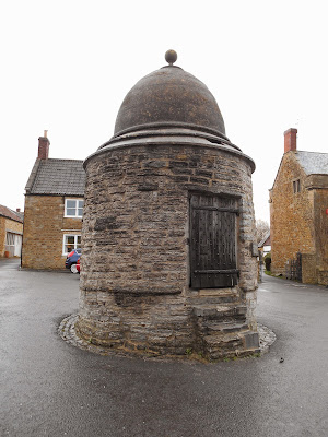
Kingbury Episcopi's octagonal lock up
This is located in the centre of the village on the village green.  It was probably built between 1820 and 1840.

 Square lock up in Mells


 Square blind house in Buckland Dinham


 Square blind house - now used as a bus shelter - in Kilmersdon

 Originally built by the churchyard wall as a guardhouse in 1785, rebuilt in its present position in 1835 on the site of the parish stocks. It was restored by the parish council in 1992.

Castle Cary's round lock up on Bailey Hill
This lock up is, according to the plaque on it, one of only 4 round lock ups in the country. It was built in 1779 at a cost of £23 by Mr W.M. Clark and was paid for by local charities.  It was repaired in 1894.  In 1922 the Lord of the Manor Sir Henry Hoare presented it to the parish council.  It has no windows but does have 2 iron grilles for ventilation.  It is 7 feet in diameter and 10 feet high.

Watchet's lock up is located round the back of the Museum


 Brompton Regis
 This lock up is adjacent to an animal pound 

Guard House in Horn Street at Nunney 
This was built in 1824 and restored in 1985.
Monkton Combe
The Monkton Combe village lock up is approximately 8ft square with a domed roof and it is built of Bath stone. It is fitted with an iron studded oak door and contains two cells.  It was built in the mid to late 18th century (possibly in 1776) and has an unusual domed roof and no windows.

 Nether Stowey
This lock up has been converted into an information point for visitors.  However when I visited in December 2015 it was being used to store road signs.

Wrington
The lock up in the High Street at Wrington looks like a small cottage sandwiched between two houses.  It was built in 1825 and it was unusual because the front half of the building was an office for the Constable.  Behind the office there were two windowless cells.

Lock up next to the parish church in Freshford
This building was later used to house the village's fire engine.


Lock up in Freshford

The west porch of the Market Hall (formerly the Town Hall) in the Market Place at Somerton was a lock up at one time


Thursday 9 April 2015

Tower Hide, Steart

There are a great many hides from which to view wildlife dotted around Somerset's many nature reserves.  However, I think the Tower Hide, which marks the beginning or end of the 50-mile River Parrett Trail is the most interesting one I have seen in the county.  It was designed by architect Wilf Burton and artist Tony Eastman in 1996 and looks like a tree house.  It also reminded me of the House in the Clouds at Thorpeness in Suffolk.  It opened in 1997 and replaced an older smaller rickety tower hide.  It looks out over the salt marsh and mudflats of the Bridgwater Bay National Nature Reserve, the lakes of Fenning Island and across the River Parrett to Burnham-on-Sea.  

There are steps inside to enable you to climb to the top level, which has windows that can be flapped upwards on all sides and at different levels, so that children can see out at their eye height level too.  For those people like my friend and I, who walked all the way from the source of the River Parrett at Winyard's Gap at Cheddington, Dorset there are plenty of benches on which to sit and rest your weary legs.  The strange metal sculpture on the top, which looks like a spaceman running is a lightning conductor.

The hide (grid reference ST 282 467) is located about 3/4 of a mile from the nearest car park and half a mile from the end of the metalled road.  There is also a permissive path, which runs along the shoreline south-west wards towards and beyond the car park.

 Tower Hide, Steart

 Tower Hide, Steart

 Tower Hide

Looking north-east towards Burnham-on-Sea from the Tower Hide.  If you squint, you can just about see the very low lying Steart Island in front of Burnham-on-Sea.  

 
Signpost at Steart with the River Parrett Trail sign

Tower Hide, December 2022

Further Reading:

The River Parrett Trail - published 1995 by the Parrett Trail Partners.  The route description and many of the contact details it contains are out of date, but it contains some useful historical information.

Up to date instructions for walking the Parrett Trail can be found on the Visit South Somerset website:

Tuesday 7 April 2015

Albert Street Cutting, Bridgwater and Taunton Canal, Bridgwater

The Bridgwater and Taunton Canal was constructed by engineer James Hollinsworth between 1824 and 1827.  It was extended into Bridgwater by engineer Thomas Maddicks 1839 to 41.The impressive Albert Street Cutting in Bridgwater has walls made of sandstone rubble, apart from a short section near West Street Bridge, which has been rebuilt with concrete blocks after a collapse in 1968. The horizontal and vertical timbers shown in the photo below were put in at this time to shore up the remaining walls.


 Wooden braces hold the walls in place for a short length between West Street and Albert Street

 Albert Street Cutting

Albert Street Cutting


Each of the 12 horizontal  beams has a line from the poem below carved into it:

POEM FOR ALBERT STREET CUTTING, BRIDGWATER

NAVIGATORS
HARD GRAFT
SINEW AND BONE
JOLT OF THE PICK
CRACK OF THE HAMMER
IRON ON STONE
RED QUANTOCK
WE CAME AND WENT
OUR LEGACY
A BOAT
COMING CLEAN
THROUGH THE HILL

The Navigators poem was composed in 1996 by local people in conjunction with writer Tony Charles. It was commissioned for the opening of the River Parrett Trail. It recalls the skill and toil needed to dig the tunnel.  The poem was carved into the beams by letter cutter Andrew Whittle. More information about the poem can be found here:
http://www.publicartonline.org.uk/casestudies/environmental/river_parrett/description.php

Further Reading:

By Waterway to Taunton: A History of the Bridgwater and Taunton Canal and the River Tone navigation by Tony Haskell.  Published by Somerset Books in 1994.

The Bridgwater and Taunton Canal by C.A. Buchanan. Published by Somerset Industrial Archaeological Society in 1984

Culvert at Haselbury Mill

A couple of friends and I were following the River Parrett Trail and just south of Haselbury Mill the presence of a geocache brought this brick culvert to our attention.  According to the plaque on the south side it was originally built in 1831 to carry water in a leat to Haselbury Mill.  It was later abandoned but was reopened in 2000 as a safe route for walkers on the Parrett Trail to pass under the busy A30.  However at the time of our visit in April 2015 it was inaccessible at the south end, due to a whole lot of branches having been dumped there.  It was possible to walk through it from the north end to look for the geocache, which I never found.  There are some shallow steps down to it on the north side bearing the words Where Water Once Flowed and there was a couple of centimetres of water in the tunnel but it was easily passable while wearing walking boots.  It hadn't rained much for several weeks prior to our visit but I would imagine that the tunnel would be impassable during wet periods.  The official route description I had for the River Parrett Trail doesn't mention the tunnel and there are steps up to the A30 and a path immediately opposite, so maybe the tunnel hasn't been in use for some time.

 Plaque commemorating the reopening of the tunnel in 2000

 Looking south down the tunnel

There was a Steam and Vintage Rally in progress at Haselbury Mill in the field adjacent to the tunnel and we enjoyed a cup of tea and some excellent cake at the vintage 1940s tea tent.  The couple running it were very friendly and had taken a great deal of time and effort to make it feel like we had gone back in time to World War 2 - they even had a working air raid siren.  It was all the more wonderful because for us it was completely unexpected.

1940s vintage pop-up tea tent

Easter Egg Ring, Burrowbridge

While walking along the River Parrett Trail from Winyard's Gap at Cheddington in Dorset to Steart on the Bristol Channel during the Easter Holiday we came across this ring of beautifully painted hard boiled eggs on Easter Sunday the east bank of the River Parrett on the edge of Burrowbridge at the point where the River Tone joins the Parrett.   I don't know what the intention of the ring's creator was but we admired the different designs, pondered on the time it must have taken to paint them all and left them where we had found them.

 Egg shaped ring of Easter Eggs with Burrow Mump in the background

 Confluence of the Rivers Tone and Parrett at Burrowbridge

Egg-shaped ring

Beautifully painted hard boiled eggs